Every Pile, Any Time™ | Stockpile Reports
  • Industry
    • Asphalt
    • Contract Crushing
    • DOTs & Public Works
    • Landscape Materials
    • Ready-Mix
  • About
  • Pricing
  • Resources
    • Help Center
    • Blog
Login
Every Pile, Any Time™ | Stockpile Reports
  • Industry
    • Contract Crushing
    • DOTs & Public Works
    • Landscape Materials
    • Ready-Mix
  • About
  • Pricing
  • Resources
    • Help Center
    • Blog
  • Login
  • Industry
    • Contract Crushing
    • DOTs & Public Works
    • Landscape Materials
    • Ready-Mix
  • About
  • Pricing
  • Resources
    • Help Center
    • Blog
  • Login

SR Measure

4
  • How To Measure a 2-Sided Bunker Pile
  • How to Measure a Freestanding Stockpile
  • How to Measure a Pile Against a Wall
  • How to Measure a 3-Sided Bunker Pile

Self-Service Drone Flights

6
  • Uploading Self-Service Drone Images to Stockpile Reports
  • What Drone and App Should You Use?
  • Viewing Your Self-Service Aerial Report
  • How to Set Up Your Drone for Measuring Inventory
  • Track Your Self-Service Aerial Uploads and Reports
  • Tagging Piles for Measurement (Self-Service Aerials)

Full Service Drone Flights

5
  • How to Schedule a Full-Service Aerial
  • Preparing Your Account for Full-Service Aerials
  • Track Your Full-Service Aerial Flights and Reports
  • Tagging Piles for Measurement (Full-Service Aerials)
  • Viewing Your Full-Service Aerial Reports

Web Portal

4
  • How To Retire a Stockpile
  • How to Manually Verify a Measurement
  • How to View and Verify Stockpile Measurement Reports
  • Camera Status Tool

Admin & Billing

8
  • How to Access Admin Tools
  • How to Fix Product Details
  • How to Manage Your Products
  • How to Update a Conversion Ratio on a Measurement
  • How to Manage Your Sites
  • How to Manage Users
  • How to Manage Your Bunkers
  • How to Clear Your Browser Cache

Troubleshooting

1
  • Contact Support
View Categories
  • Docs
  • Self-Service Drone Flights
  • Uploading Self-Service Drone Images to Stockpile Reports

Uploading Self-Service Drone Images to Stockpile Reports

After completing a self-service drone flight, follow the steps below to upload your images so Stockpile Reports can process your measurements.


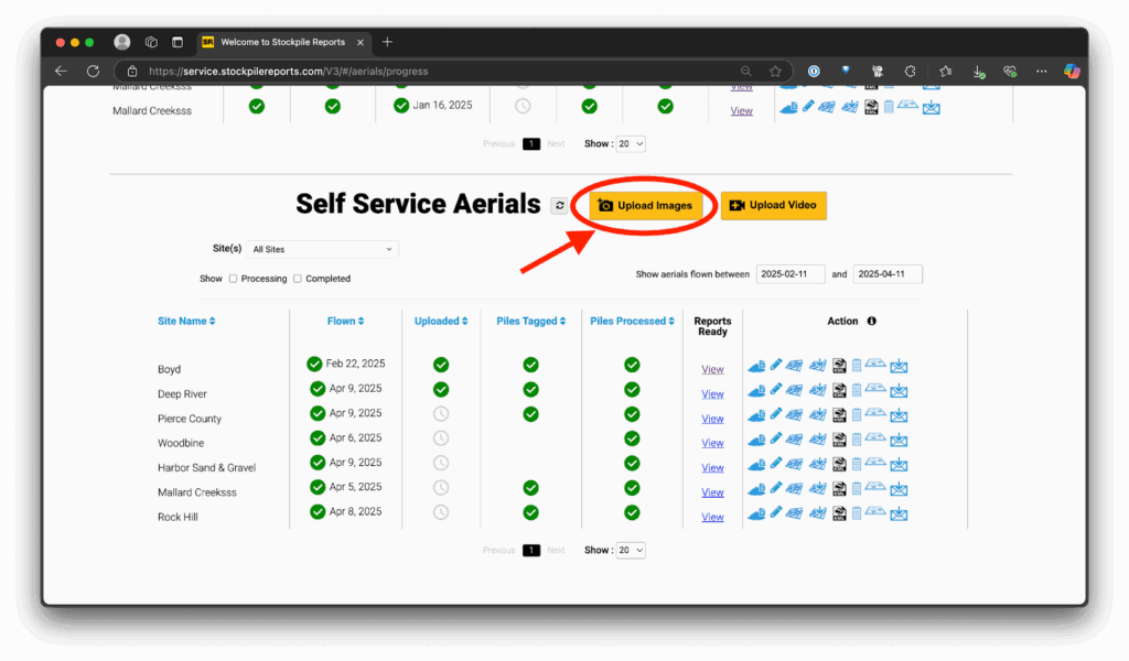
  1. In the Stockpile Reports web portal, click the Aerials tab in the top-right corner.
  1. On the aerials page, scroll down to Self-Service Aerials
  2. Click the Upload Images button.
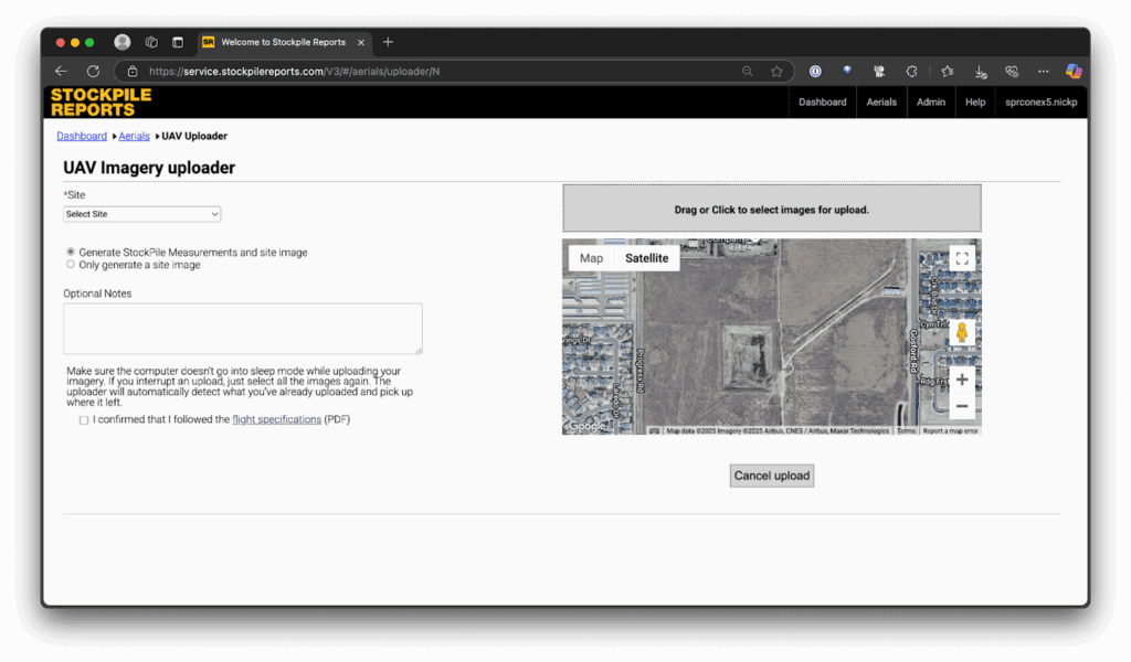
  1. On the UAV Image Uploader page:
    • Site: Select the site where you flew.
    • Generate Stockpile Measurements and site image: Choose this if you want pile measurements. If you only want a site image, select Only generate a site image.
    • Optional Notes: Add details about the flight, location, or conditions.
    • Flight Specifications: Review to confirm your flight meets Stockpile Reports requirements.
    • Upload Images: Drag and drop or click to select your flight images.

Copy images from your drone’s SD card onto your computer first. Uploading directly from the SD card can cause buffering issues that stop the upload and force you to restart.

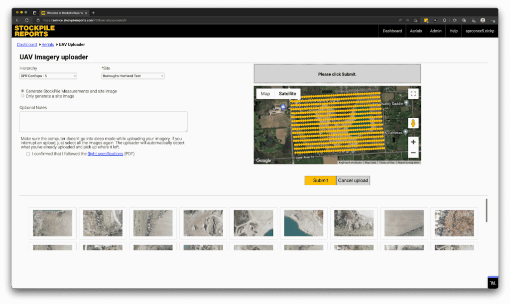
  1. Google Map View: Confirms GPS positions of uploaded images to verify complete coverage.
  1. After confirming your images are correct, click Submit.

Keep your computer awake during upload. If your computer turns off or goes to sleep, the upload will fail before completion.

After submitting your images, Stockpile Reports will process your flight.

Updated on October 7, 2025
Business

What are your feelings

What Drone and App Should You Use?
Every Pile, Any Time™ | Stockpile Reports

8201 164th Ave NE, PMB 55

Redmond, WA 98052

Quick Links

About

Pricing

Blog

Contact

(425) 428-5266

Send us a message

  • Follow
  • Follow
  • Follow
  • Follow
  • Follow

© Copyright Stockpile Reports 2025. Privacy Policy.